


calanques de cassis

Michel DUBOIS
User
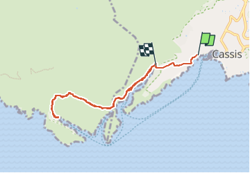

Length
8.1 km

Max alt
137 m

Uphill gradient
387 m
Km-Effort
13.2 km

Min alt
4 m

Downhill gradient
384 m
Boucle
No
Creation date :
2022-05-19 07:32:21.558
Updated on :
2022-05-19 12:07:16.442
2h22
Difficulty : Medium

FREE GPS app for hiking
 SityTrail
IGN / Geographical institutes
SityTrail Plus
The world is yours!
About
Trail Walking of 8.1 km to be discovered at Provence-Alpes-Côte d'Azur, Bouches-du-Rhône, Cassis. This trail is proposed by Michel DUBOIS.
Description
à faire à la fraîche le matin
Positioning
Country:
France
Region :
Provence-Alpes-Côte d'Azur
Department/Province :
Bouches-du-Rhône
Municipality :
Cassis
Location:
Unknown
Start:(Dec)
Start:(UTM)
705697 ; 4787675 (31T) N.
Comments