


Champigneules

topnature !
User
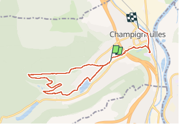

Length
8.6 km

Max alt
310 m

Uphill gradient
133 m
Km-Effort
10.4 km

Min alt
194 m

Downhill gradient
143 m
Boucle
No
Creation date :
2022-05-20 12:31:28.0
Updated on :
2022-05-20 14:58:02.079
2h25
Difficulty : Medium

FREE GPS app for hiking
 SityTrail
IGN / Geographical institutes
SityTrail Plus
The world is yours!
About
Trail Walking of 8.6 km to be discovered at Grand Est, Meurthe-et-Moselle, Champigneulles. This trail is proposed by topnature !.
Description
Forêt
Positioning
Country:
France
Region :
Grand Est
Department/Province :
Meurthe-et-Moselle
Municipality :
Champigneulles
Location:
Unknown
Start:(Dec)
Start:(UTM)
290852 ; 5401126 (32U) N.
Comments