


Préparation Vosges

nicolas54230
User

Length
27 km

Max alt
423 m

Uphill gradient
344 m
Km-Effort
31 km

Min alt
331 m

Downhill gradient
343 m
Boucle
Yes
Creation date :
2022-05-21 08:07:50.21
Updated on :
2022-05-21 13:03:18.098
4h53
Difficulty : Difficult

FREE GPS app for hiking
 SityTrail
IGN / Geographical institutes
SityTrail Plus
The world is yours!
About
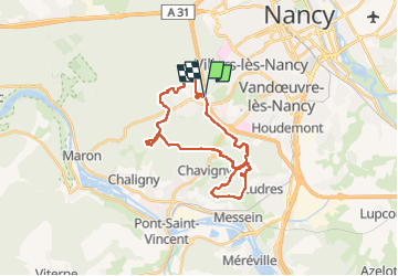
Trail Mountain bike of 27 km to be discovered at Grand Est, Meurthe-et-Moselle, Villers-lès-Nancy. This trail is proposed by nicolas54230.
Positioning
Country:
France
Region :
Grand Est
Department/Province :
Meurthe-et-Moselle
Municipality :
Villers-lès-Nancy
Location:
Unknown
Start:(Dec)
Start:(UTM)
288285 ; 5393575 (32U) N.
Comments