


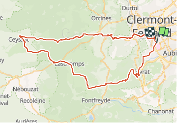
Cols de Ceyssat et de la Moreno en partant de St Jacques

PsyPezman
User

Length
43 km

Max alt
1082 m

Uphill gradient
1062 m
Km-Effort
57 km

Min alt
380 m

Downhill gradient
1061 m
Boucle
Yes
Creation date :
2022-05-21 07:43:42.389
Updated on :
2022-05-22 10:01:53.096
3h09
Difficulty : Very difficult

FREE GPS app for hiking
 SityTrail
IGN / Geographical institutes
SityTrail Plus
The world is yours!
About
Trail Road bike of 43 km to be discovered at Auvergne-Rhône-Alpes, Puy-de-Dôme, Clermont-Ferrand. This trail is proposed by PsyPezman.
Positioning
Country:
France
Region :
Auvergne-Rhône-Alpes
Department/Province :
Puy-de-Dôme
Municipality :
Clermont-Ferrand
Location:
Unknown
Start:(Dec)
Start:(UTM)
506963 ; 5067501 (31T) N.
Comments