


Boucle Château d'Abbadie - Pointe Ste.Anne

rigol05
User
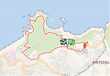

Length
6.4 km

Max alt
69 m

Uphill gradient
115 m
Km-Effort
7.9 km

Min alt
10 m

Downhill gradient
117 m
Boucle
Yes
Creation date :
2022-05-20 13:07:53.894
Updated on :
2022-06-28 07:15:26.427
1h30
Difficulty : Easy

FREE GPS app for hiking
 SityTrail
IGN / Geographical institutes
SityTrail Plus
The world is yours!
About
Trail Walking of 6.4 km to be discovered at New Aquitaine, Pyrénées-Atlantiques, Hendaye. This trail is proposed by rigol05.
Description
Séjour Landes
Sortie du 20/05/2022
Positioning
Country:
France
Region :
New Aquitaine
Department/Province :
Pyrénées-Atlantiques
Municipality :
Hendaye
Location:
Unknown
Start:(Dec)
Start:(UTM)
601768 ; 4803454 (30T) N.
Comments