


flat les 3 village bis

jeanic63
User

Length
12.1 km

Max alt
642 m

Uphill gradient
381 m
Km-Effort
17.2 km

Min alt
414 m

Downhill gradient
384 m
Boucle
Yes
Creation date :
2022-05-22 06:29:13.86
Updated on :
2022-05-22 09:41:51.016
2h44
Difficulty : Difficult

FREE GPS app for hiking
 SityTrail
IGN / Geographical institutes
SityTrail Plus
The world is yours!
About
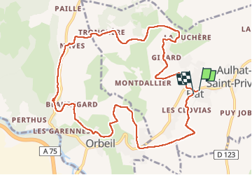
Trail Walking of 12.1 km to be discovered at Auvergne-Rhône-Alpes, Puy-de-Dôme, Aulhat-Flat. This trail is proposed by jeanic63.
Description
départ flat
Positioning
Country:
France
Region :
Auvergne-Rhône-Alpes
Department/Province :
Puy-de-Dôme
Municipality :
Aulhat-Flat
Location:
Unknown
Start:(Dec)
Start:(UTM)
523677 ; 5046403 (31T) N.
Comments