


De camaret a pen-hirc

eric.deniau
User
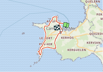

Length
11.9 km

Max alt
59 m

Uphill gradient
204 m
Km-Effort
14.6 km

Min alt
-2 m

Downhill gradient
203 m
Boucle
No
Creation date :
2022-05-22 07:46:47.0
Updated on :
2022-05-22 12:55:10.718
4h12
Difficulty : Difficult

FREE GPS app for hiking
 SityTrail
IGN / Geographical institutes
SityTrail Plus
The world is yours!
About
Trail Walking of 11.9 km to be discovered at Brittany, Finistère, Camaret-sur-Mer. This trail is proposed by eric.deniau.
Positioning
Country:
France
Region :
Brittany
Department/Province :
Finistère
Municipality :
Camaret-sur-Mer
Location:
Unknown
Start:(Dec)
Start:(UTM)
381645 ; 5348075 (30U) N.
Comments