


Nant sainte eulalie

Glurps
User
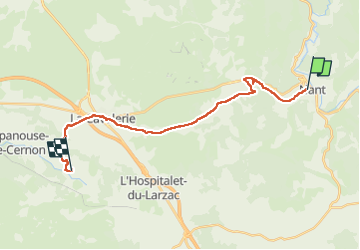

Length
22 km

Max alt
845 m

Uphill gradient
513 m
Km-Effort
29 km

Min alt
495 m

Downhill gradient
412 m
Boucle
No
Creation date :
2022-05-22 06:52:19.0
Updated on :
2022-05-22 15:11:45.078
5h57
Difficulty : Difficult

FREE GPS app for hiking
 SityTrail
IGN / Geographical institutes
SityTrail Plus
The world is yours!
About
Trail Walking of 22 km to be discovered at Occitania, Aveyron, Nant. This trail is proposed by Glurps.
Photos


Positioning
Country:
France
Region :
Occitania
Department/Province :
Aveyron
Municipality :
Nant
Location:
Unknown
Start:(Dec)
Start:(UTM)
523888 ; 4874395 (31T) N.
Comments