


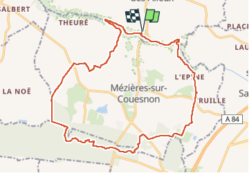
St Ouen Des Alleux Pkg La Coursonnière-Forêt de St Aubin (Zone humide) 21km JY

COGLAIS3
User

Length
21 km

Max alt
117 m

Uphill gradient
274 m
Km-Effort
25 km

Min alt
43 m

Downhill gradient
275 m
Boucle
Yes
Creation date :
2022-05-24 06:08:35.448
Updated on :
2022-05-25 19:49:45.974
3h57
Difficulty : Easy

FREE GPS app for hiking
 SityTrail
IGN / Geographical institutes
SityTrail Plus
The world is yours!
About
Trail Nordic walking of 21 km to be discovered at Brittany, Ille-et-Vilaine, Saint-Ouen-des-Alleux. This trail is proposed by COGLAIS3.
Positioning
Country:
France
Region :
Brittany
Department/Province :
Ille-et-Vilaine
Municipality :
Saint-Ouen-des-Alleux
Location:
Unknown
Start:(Dec)
Start:(UTM)
616372 ; 5352502 (30U) N.
Comments