Combovin

raygautier
User
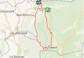

Length
14.6 km

Max alt
791 m

Uphill gradient
526 m
Km-Effort
22 km

Min alt
358 m

Downhill gradient
604 m
Boucle
No
Creation date :
2022-05-22 07:44:56.0
Updated on :
2022-05-25 05:40:09.211
67h31
Difficulty : Very difficult

FREE GPS app for hiking
 SityTrail
IGN / Geographical institutes
SityTrail Plus
The world is yours!
About
Trail Walking of 14.6 km to be discovered at Auvergne-Rhône-Alpes, Drôme, Combovin. This trail is proposed by raygautier.
Positioning
Country:
France
Region :
Auvergne-Rhône-Alpes
Department/Province :
Drôme
Municipality :
Combovin
Location:
Unknown
Start:(Dec)
Start:(UTM)
664371 ; 4970453 (31T) N.
Comments