


19.07.14-Gaschney-Schiessrothried-Blanchemer-Lande-Falimont-Gaschney

delm
User
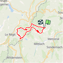

Length
22 km

Max alt
1341 m

Uphill gradient
1018 m
Km-Effort
36 km

Min alt
890 m

Downhill gradient
1015 m
Boucle
Yes
Creation date :
2014-12-10 00:00:00.0
Updated on :
2014-12-10 00:00:00.0
5h00
Difficulty : Unknown

FREE GPS app for hiking
 SityTrail
IGN / Geographical institutes
SityTrail Plus
The world is yours!
About
Trail Walking of 22 km to be discovered at Grand Est, Haut-Rhin, Stosswihr. This trail is proposed by delm.
Positioning
Country:
France
Region :
Grand Est
Department/Province :
Haut-Rhin
Municipality :
Stosswihr
Location:
Unknown
Start:(Dec)
Start:(UTM)
354382 ; 5321953 (32U) N.
Comments