


Verignon

astein
User
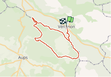

Length
18.4 km

Max alt
1074 m

Uphill gradient
705 m
Km-Effort
28 km

Min alt
627 m

Downhill gradient
701 m
Boucle
Yes
Creation date :
2022-05-25 06:19:51.0
Updated on :
2022-05-25 12:12:54.425
4h36
Difficulty : Difficult

FREE GPS app for hiking
 SityTrail
IGN / Geographical institutes
SityTrail Plus
The world is yours!
About
Trail Walking of 18.4 km to be discovered at Provence-Alpes-Côte d'Azur, Var, Vérignon. This trail is proposed by astein.
Positioning
Country:
France
Region :
Provence-Alpes-Côte d'Azur
Department/Province :
Var
Municipality :
Vérignon
Location:
Unknown
Start:(Dec)
Start:(UTM)
280157 ; 4837010 (32T) N.
Comments