


g3 sabots

papou73
User
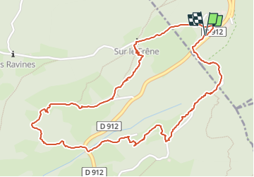

Length
3.1 km

Max alt
1168 m

Uphill gradient
97 m
Km-Effort
4.5 km

Min alt
1073 m

Downhill gradient
100 m
Boucle
Yes
Creation date :
2022-05-25 12:12:18.945
Updated on :
2022-05-25 13:37:48.416
1h00
Difficulty : Easy

FREE GPS app for hiking
 SityTrail
IGN / Geographical institutes
SityTrail Plus
The world is yours!
About
Trail Walking of 3.1 km to be discovered at Auvergne-Rhône-Alpes, Savoy, Apremont. This trail is proposed by papou73.
Photos


Positioning
Country:
France
Region :
Auvergne-Rhône-Alpes
Department/Province :
Savoy
Municipality :
Apremont
Location:
Unknown
Start:(Dec)
Start:(UTM)
727710 ; 5040367 (31T) N.
Comments