


annecy 2
© OpenStreetMap contributors


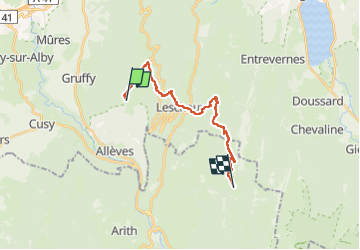
6h06
Difficulty : Very difficult


Length
16.6 km
Max alt
1661 m
Uphill gradient
687 m
Km-Effort
28 km
Min alt
898 m
Downhill gradient
1226 m
Boucle
No
Creation date :
2022-05-25 19:32:32.246
Updated on :
2022-05-25 19:37:36.442
6h06
Difficulty : Very difficult
FREE GPS app for hiking
 SityTrail
IGN / Geographical institutes
SityTrail Plus
The world is yours!
About
Trail Walking of 16.6 km to be discovered at Auvergne-Rhône-Alpes, Upper Savoy, Gruffy. This trail is proposed by jerome-dupont@laposte.net.
Description
rando claire et romain
Positioning
Country:
France
Region :
Auvergne-Rhône-Alpes
Department/Province :
Upper Savoy
Municipality :
Gruffy
Location:
Unknown
Start:(Dec)
Start:(UTM)
273669 ; 5073282 (32T) N.
Comments