


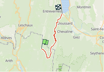
annecy 3
© OpenStreetMap contributors


5h28
Difficulty : Very difficult


Length
15.5 km
Max alt
1436 m
Uphill gradient
499 m
Km-Effort
24 km
Min alt
453 m
Downhill gradient
1078 m
Boucle
No
Creation date :
2022-05-25 19:42:47.08
Updated on :
2022-05-25 19:43:09.501
5h28
Difficulty : Very difficult
FREE GPS app for hiking
 SityTrail
IGN / Geographical institutes
SityTrail Plus
The world is yours!
About
Trail Walking of 15.5 km to be discovered at Auvergne-Rhône-Alpes, Savoy, Bellecombe-en-Bauges. This trail is proposed by jerome-dupont@laposte.net.
Positioning
Country:
France
Region :
Auvergne-Rhône-Alpes
Department/Province :
Savoy
Municipality :
Bellecombe-en-Bauges
Location:
Unknown
Start:(Dec)
Start:(UTM)
279372 ; 5068397 (32T) N.
Comments