


tour des monts du lyonnais

bena42
User
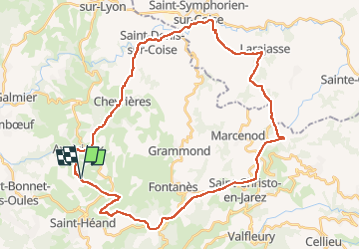

Length
41 km

Max alt
935 m

Uphill gradient
1149 m
Km-Effort
56 km

Min alt
464 m

Downhill gradient
1150 m
Boucle
Yes
Creation date :
2022-05-26 06:35:56.451
Updated on :
2022-05-26 11:47:33.867
4h28
Difficulty : Very difficult

FREE GPS app for hiking
 SityTrail
IGN / Geographical institutes
SityTrail Plus
The world is yours!
About
Trail Mountain bike of 41 km to be discovered at Auvergne-Rhône-Alpes, Loire, Saint-Héand. This trail is proposed by bena42.
Positioning
Country:
France
Region :
Auvergne-Rhône-Alpes
Department/Province :
Loire
Municipality :
Saint-Héand
Location:
Unknown
Start:(Dec)
Start:(UTM)
607279 ; 5045128 (31T) N.
Comments