Chemin_de_Stevenson_#J6_Florac_-_Cassagnas

BureauChris
User
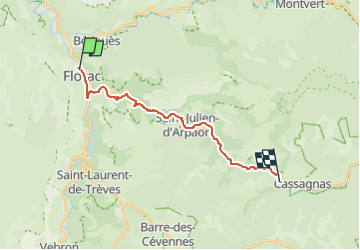

Length
17.5 km

Max alt
719 m

Uphill gradient
450 m
Km-Effort
23 km

Min alt
544 m

Downhill gradient
300 m
Boucle
No
Creation date :
2022-05-26 14:47:16.012
Updated on :
2022-05-26 14:48:00.947
5h13
Difficulty : Very difficult

FREE GPS app for hiking
 SityTrail
IGN / Geographical institutes
SityTrail Plus
The world is yours!
About
Trail Walking of 17.5 km to be discovered at Occitania, Lozère, Florac Trois Rivières. This trail is proposed by BureauChris.
Positioning
Country:
France
Region :
Occitania
Department/Province :
Lozère
Municipality :
Florac Trois Rivières
Location:
Florac
Start:(Dec)
Start:(UTM)
547223 ; 4908309 (31T) N.
Comments