Chemin_de_Stevenson_#J7_Cassagnas_-_Saint-Germain-de-Calberte

BureauChris
User
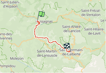

Length
15.5 km

Max alt
1032 m

Uphill gradient
407 m
Km-Effort
22 km

Min alt
494 m

Downhill gradient
610 m
Boucle
No
Creation date :
2022-05-26 14:48:26.72
Updated on :
2022-05-26 14:49:34.776
4h54
Difficulty : Very difficult

FREE GPS app for hiking
 SityTrail
IGN / Geographical institutes
SityTrail Plus
The world is yours!
About
Trail Walking of 15.5 km to be discovered at Occitania, Lozère, Cassagnas. This trail is proposed by BureauChris.
Positioning
Country:
France
Region :
Occitania
Department/Province :
Lozère
Municipality :
Cassagnas
Location:
Unknown
Start:(Dec)
Start:(UTM)
558294 ; 4902312 (31T) N.
Comments