


jour 2

Tommy Eric
User
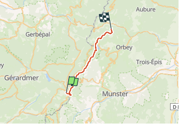

Length
23 km

Max alt
1352 m

Uphill gradient
682 m
Km-Effort
33 km

Min alt
933 m

Downhill gradient
937 m
Boucle
No
Creation date :
2022-05-26 07:12:29.184
Updated on :
2022-05-26 16:09:02.514
8h47
Difficulty : Very difficult

FREE GPS app for hiking
 SityTrail
IGN / Geographical institutes
SityTrail Plus
The world is yours!
About
Trail Walking of 23 km to be discovered at Grand Est, Vosges, Xonrupt-Longemer. This trail is proposed by Tommy Eric.
Positioning
Country:
France
Region :
Grand Est
Department/Province :
Vosges
Municipality :
Xonrupt-Longemer
Location:
Unknown
Start:(Dec)
Start:(UTM)
351150 ; 5323007 (32U) N.
Comments