


Granges-Joigny-G1+

Valmeinier
User
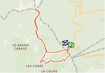

Length
8.9 km

Max alt
1476 m

Uphill gradient
473 m
Km-Effort
15.2 km

Min alt
1073 m

Downhill gradient
471 m
Boucle
Yes
Creation date :
2022-05-27 05:48:33.529
Updated on :
2022-05-27 05:48:33.529
3h26
Difficulty : Difficult

FREE GPS app for hiking
 SityTrail
IGN / Geographical institutes
SityTrail Plus
The world is yours!
About
Trail Walking of 8.9 km to be discovered at Auvergne-Rhône-Alpes, Savoy, Apremont. This trail is proposed by Valmeinier.
Positioning
Country:
France
Region :
Auvergne-Rhône-Alpes
Department/Province :
Savoy
Municipality :
Apremont
Location:
Unknown
Start:(Dec)
Start:(UTM)
727649 ; 5040320 (31T) N.
Comments