


26

Divio
User
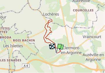

Length
9.3 km

Max alt
296 m

Uphill gradient
204 m
Km-Effort
12 km

Min alt
211 m

Downhill gradient
203 m
Boucle
Yes
Creation date :
2022-05-27 06:33:28.655
Updated on :
2022-05-27 08:48:27.934
2h14
Difficulty : Very easy

FREE GPS app for hiking
 SityTrail
IGN / Geographical institutes
SityTrail Plus
The world is yours!
About
Trail Nordic walking of 9.3 km to be discovered at Grand Est, Meuse, Clermont-en-Argonne. This trail is proposed by Divio.
Description
ni un ni#on@
Positioning
Country:
France
Region :
Grand Est
Department/Province :
Meuse
Municipality :
Clermont-en-Argonne
Location:
Unknown
Start:(Dec)
Start:(UTM)
649900 ; 5441115 (31U) N.
Comments