


Tour du lac d'Annecy

PhilippeC54
User
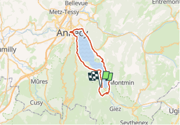

Length
42 km

Max alt
557 m

Uphill gradient
501 m
Km-Effort
48 km

Min alt
445 m

Downhill gradient
501 m
Boucle
Yes
Creation date :
2022-05-27 07:23:55.418
Updated on :
2022-05-27 10:53:15.637
2h34
Difficulty : Easy

FREE GPS app for hiking
 SityTrail
IGN / Geographical institutes
SityTrail Plus
The world is yours!
About
Trail Road bike of 42 km to be discovered at Auvergne-Rhône-Alpes, Upper Savoy, Lathuile. This trail is proposed by PhilippeC54.
Positioning
Country:
France
Region :
Auvergne-Rhône-Alpes
Department/Province :
Upper Savoy
Municipality :
Lathuile
Location:
Unknown
Start:(Dec)
Start:(UTM)
283031 ; 5075011 (32T) N.
Comments