


Col de la Forclaz

PhilippeC54
User
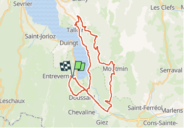

Length
36 km

Max alt
1155 m

Uphill gradient
888 m
Km-Effort
47 km

Min alt
447 m

Downhill gradient
888 m
Boucle
Yes
Creation date :
2022-05-27 12:19:48.454
Updated on :
2022-05-27 14:26:43.777
1h59
Difficulty : Difficult

FREE GPS app for hiking
 SityTrail
IGN / Geographical institutes
SityTrail Plus
The world is yours!
About
Trail Road bike of 36 km to be discovered at Auvergne-Rhône-Alpes, Upper Savoy, Lathuile. This trail is proposed by PhilippeC54.
Positioning
Country:
France
Region :
Auvergne-Rhône-Alpes
Department/Province :
Upper Savoy
Municipality :
Lathuile
Location:
Unknown
Start:(Dec)
Start:(UTM)
283027 ; 5075012 (32T) N.
Comments
col de la forclaz