


Col de Leschaux

PhilippeC54
User
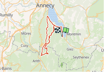

Length
59 km

Max alt
955 m

Uphill gradient
1145 m
Km-Effort
74 km

Min alt
448 m

Downhill gradient
1145 m
Boucle
Yes
Creation date :
2022-05-28 06:44:00.287
Updated on :
2022-05-28 10:42:11.708
3h31
Difficulty : Difficult

FREE GPS app for hiking
 SityTrail
IGN / Geographical institutes
SityTrail Plus
The world is yours!
About
Trail Road bike of 59 km to be discovered at Auvergne-Rhône-Alpes, Upper Savoy, Lathuile. This trail is proposed by PhilippeC54.
Positioning
Country:
France
Region :
Auvergne-Rhône-Alpes
Department/Province :
Upper Savoy
Municipality :
Lathuile
Location:
Unknown
Start:(Dec)
Start:(UTM)
283028 ; 5075007 (32T) N.
Comments