


Saint MENOUx

pierrol
User
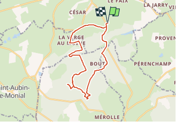

Length
15.1 km

Max alt
334 m

Uphill gradient
259 m
Km-Effort
18.6 km

Min alt
243 m

Downhill gradient
259 m
Boucle
Yes
Creation date :
2022-05-28 11:55:36.598
Updated on :
2022-05-28 14:06:47.384
4h13
Difficulty : Difficult

FREE GPS app for hiking
 SityTrail
IGN / Geographical institutes
SityTrail Plus
The world is yours!
About
Trail Walking of 15.1 km to be discovered at Auvergne-Rhône-Alpes, Allier, Bourbon-l'Archambault. This trail is proposed by pierrol.
Positioning
Country:
France
Region :
Auvergne-Rhône-Alpes
Department/Province :
Allier
Municipality :
Bourbon-l'Archambault
Location:
Unknown
Start:(Dec)
Start:(UTM)
505259 ; 5156317 (31T) N.
Comments