


st jean d'arvey/passage de la dorette/ mont peney/cascade de la doria

inesmyt
User
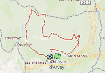

Length
11.2 km

Max alt
1349 m

Uphill gradient
880 m
Km-Effort
23 km

Min alt
588 m

Downhill gradient
882 m
Boucle
Yes
Creation date :
2022-05-28 09:43:51.695
Updated on :
2022-05-28 14:26:11.262
4h40
Difficulty : Very difficult

FREE GPS app for hiking
 SityTrail
IGN / Geographical institutes
SityTrail Plus
The world is yours!
About
Trail Walking of 11.2 km to be discovered at Auvergne-Rhône-Alpes, Savoy, Saint-Jean-d'Arvey. This trail is proposed by inesmyt.
Positioning
Country:
France
Region :
Auvergne-Rhône-Alpes
Department/Province :
Savoy
Municipality :
Saint-Jean-d'Arvey
Location:
Unknown
Start:(Dec)
Start:(UTM)
733549 ; 5052498 (31T) N.
Comments