


Les Roches St Jacques

noelphil
User
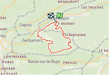

Length
12.7 km

Max alt
1025 m

Uphill gradient
541 m
Km-Effort
19.9 km

Min alt
539 m

Downhill gradient
540 m
Boucle
Yes
Creation date :
2022-05-28 12:43:04.206
Updated on :
2022-05-28 16:39:39.714
3h55
Difficulty : Very difficult

FREE GPS app for hiking
 SityTrail
IGN / Geographical institutes
SityTrail Plus
The world is yours!
About
Trail Walking of 12.7 km to be discovered at Grand Est, Vosges, Rochesson. This trail is proposed by noelphil.
Positioning
Country:
France
Region :
Grand Est
Department/Province :
Vosges
Municipality :
Rochesson
Location:
Unknown
Start:(Dec)
Start:(UTM)
334566 ; 5320830 (32U) N.
Comments