


houat1

bourdet
User

Length
8.2 km

Max alt
25 m

Uphill gradient
85 m
Km-Effort
9.3 km

Min alt
0 m

Downhill gradient
101 m
Boucle
No
Creation date :
2022-05-29 08:47:24.306
Updated on :
2022-05-29 11:32:04.688
2h44
Difficulty : Medium

FREE GPS app for hiking
 SityTrail
IGN / Geographical institutes
SityTrail Plus
The world is yours!
About
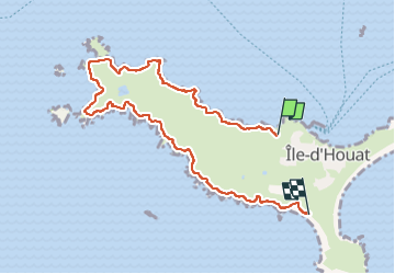
Trail Walking of 8.2 km to be discovered at Brittany, Morbihan, Île-d'Houat. This trail is proposed by bourdet.
Positioning
Country:
France
Region :
Brittany
Department/Province :
Morbihan
Municipality :
Île-d'Houat
Location:
Unknown
Start:(Dec)
Start:(UTM)
502790 ; 5248740 (30T) N.
Comments