


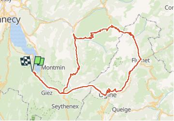
Cols du Marais, de la Croix Fry et des Aravis

PhilippeC54
User

Length
96 km

Max alt
1488 m

Uphill gradient
2378 m
Km-Effort
127 km

Min alt
412 m

Downhill gradient
2378 m
Boucle
Yes
Creation date :
2022-05-30 07:05:20.431
Updated on :
2022-05-30 12:59:58.415
5h15
Difficulty : Very difficult

FREE GPS app for hiking
 SityTrail
IGN / Geographical institutes
SityTrail Plus
The world is yours!
About
Trail Road bike of 96 km to be discovered at Auvergne-Rhône-Alpes, Upper Savoy, Lathuile. This trail is proposed by PhilippeC54.
Positioning
Country:
France
Region :
Auvergne-Rhône-Alpes
Department/Province :
Upper Savoy
Municipality :
Lathuile
Location:
Unknown
Start:(Dec)
Start:(UTM)
282993 ; 5075036 (32T) N.
Comments