


Saury

PhilippeC54
User
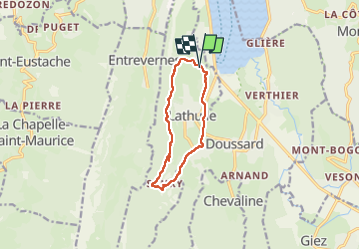

Length
9.6 km

Max alt
762 m

Uphill gradient
369 m
Km-Effort
14.5 km

Min alt
451 m

Downhill gradient
370 m
Boucle
Yes
Creation date :
2022-05-31 08:26:59.782
Updated on :
2022-05-31 11:18:17.154
2h31
Difficulty : Easy

FREE GPS app for hiking
 SityTrail
IGN / Geographical institutes
SityTrail Plus
The world is yours!
About
Trail Walking of 9.6 km to be discovered at Auvergne-Rhône-Alpes, Upper Savoy, Lathuile. This trail is proposed by PhilippeC54.
Positioning
Country:
France
Region :
Auvergne-Rhône-Alpes
Department/Province :
Upper Savoy
Municipality :
Lathuile
Location:
Unknown
Start:(Dec)
Start:(UTM)
283005 ; 5075026 (32T) N.
Comments