


Randonnée SRAV-Fun Club

nicolas54230
User
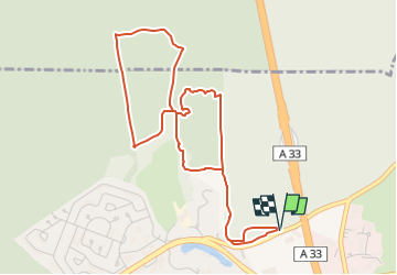

Length
4.9 km

Max alt
363 m

Uphill gradient
73 m
Km-Effort
5.9 km

Min alt
324 m

Downhill gradient
73 m
Boucle
Yes
Creation date :
2022-06-01 09:10:17.989
Updated on :
2022-06-01 09:11:05.561
1h20
Difficulty : Easy

FREE GPS app for hiking
 SityTrail
IGN / Geographical institutes
SityTrail Plus
The world is yours!
About
Trail Walking of 4.9 km to be discovered at Grand Est, Meurthe-et-Moselle, Villers-lès-Nancy. This trail is proposed by nicolas54230.
Positioning
Country:
France
Region :
Grand Est
Department/Province :
Meurthe-et-Moselle
Municipality :
Villers-lès-Nancy
Location:
Unknown
Start:(Dec)
Start:(UTM)
288198 ; 5393570 (32U) N.
Comments