


Massif rocher canon Fontainebleau 18km

jeanmarcMasson
User GUIDE
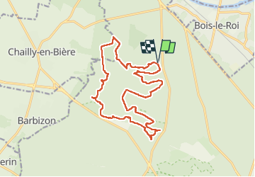

Length
18.4 km

Max alt
154 m

Uphill gradient
256 m
Km-Effort
22 km

Min alt
86 m

Downhill gradient
256 m
Boucle
Yes
Creation date :
2022-06-01 07:48:22.118
Updated on :
2022-06-01 14:02:49.137
4h48
Difficulty : Very difficult

FREE GPS app for hiking
 SityTrail
IGN / Geographical institutes
SityTrail Plus
The world is yours!
About
Trail Walking of 18.4 km to be discovered at Ile-de-France, Seine-et-Marne, Fontainebleau. This trail is proposed by jeanmarcMasson.
Positioning
Country:
France
Region :
Ile-de-France
Department/Province :
Seine-et-Marne
Municipality :
Fontainebleau
Location:
Unknown
Start:(Dec)
Start:(UTM)
475284 ; 5367860 (31U) N.
Comments