


Le Malpassant - St Saturnin

PhilippeC54
User
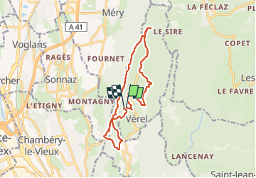

Length
14.9 km

Max alt
981 m

Uphill gradient
756 m
Km-Effort
25 km

Min alt
404 m

Downhill gradient
761 m
Boucle
Yes
Creation date :
2022-06-02 07:40:39.256
Updated on :
2022-06-02 14:15:39.906
4h32
Difficulty : Medium

FREE GPS app for hiking
 SityTrail
IGN / Geographical institutes
SityTrail Plus
The world is yours!
About
Trail Walking of 14.9 km to be discovered at Auvergne-Rhône-Alpes, Savoy, Verel-Pragondran. This trail is proposed by PhilippeC54.
Positioning
Country:
France
Region :
Auvergne-Rhône-Alpes
Department/Province :
Savoy
Municipality :
Verel-Pragondran
Location:
Unknown
Start:(Dec)
Start:(UTM)
729535 ; 5055013 (31T) N.
Comments