


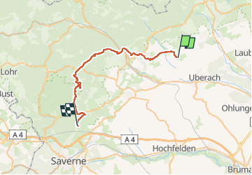
UHRWILLER Ernolsheim

Rémy Isenmann
User

Length
33 km

Max alt
374 m

Uphill gradient
568 m
Km-Effort
40 km

Min alt
182 m

Downhill gradient
539 m
Boucle
No
Creation date :
2022-06-05 05:22:25.7
Updated on :
2022-06-05 10:06:23.794
3h35
Difficulty : Medium

FREE GPS app for hiking
 SityTrail
IGN / Geographical institutes
SityTrail Plus
The world is yours!
About
Trail Coupling of 33 km to be discovered at Grand Est, Bas-Rhin, Uhrwiller. This trail is proposed by Rémy Isenmann.
Description
UHRWILLER Ernolsheim
Positioning
Country:
France
Region :
Grand Est
Department/Province :
Bas-Rhin
Municipality :
Uhrwiller
Location:
Unknown
Start:(Dec)
Start:(UTM)
395718 ; 5414617 (32U) N.
Comments