


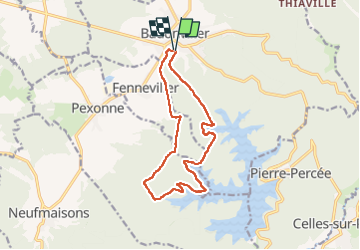
Rando des lacs

audrey54
User

Length
13.5 km

Max alt
431 m

Uphill gradient
272 m
Km-Effort
17.1 km

Min alt
312 m

Downhill gradient
273 m
Boucle
Yes
Creation date :
2022-06-05 07:15:20.0
Updated on :
2022-06-05 10:22:32.985
3h06
Difficulty : Easy

FREE GPS app for hiking
 SityTrail
IGN / Geographical institutes
SityTrail Plus
The world is yours!
About
Trail Walking of 13.5 km to be discovered at Grand Est, Meurthe-et-Moselle, Badonviller. This trail is proposed by audrey54.
Positioning
Country:
France
Region :
Grand Est
Department/Province :
Meurthe-et-Moselle
Municipality :
Badonviller
Location:
Unknown
Start:(Dec)
Start:(UTM)
344348 ; 5373611 (32U) N.
Comments