


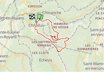
Chatelus

Monjean
User

Length
14.7 km

Max alt
1289 m

Uphill gradient
1177 m
Km-Effort
30 km

Min alt
525 m

Downhill gradient
1176 m
Boucle
Yes
Creation date :
2022-06-05 06:27:26.439
Updated on :
2022-06-05 12:09:33.582
5h41
Difficulty : Very difficult

FREE GPS app for hiking
 SityTrail
IGN / Geographical institutes
SityTrail Plus
The world is yours!
About
Trail Walking of 14.7 km to be discovered at Auvergne-Rhône-Alpes, Isère, Châtelus. This trail is proposed by Monjean.
Description
pas de Charmatte
Positioning
Country:
France
Region :
Auvergne-Rhône-Alpes
Department/Province :
Isère
Municipality :
Châtelus
Location:
Unknown
Start:(Dec)
Start:(UTM)
686863 ; 4992088 (31T) N.
Comments