


circuit des sources

mannequ1
User
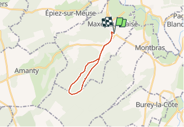

Length
8.5 km

Max alt
389 m

Uphill gradient
153 m
Km-Effort
10.6 km

Min alt
259 m

Downhill gradient
152 m
Boucle
Yes
Creation date :
2014-12-10 00:00:00.0
Updated on :
2014-12-10 00:00:00.0
2h17
Difficulty : Easy

FREE GPS app for hiking
 SityTrail
IGN / Geographical institutes
SityTrail Plus
The world is yours!
About
Trail Walking of 8.5 km to be discovered at Grand Est, Meuse, Maxey-sur-Vaise. This trail is proposed by mannequ1.
Positioning
Country:
France
Region :
Grand Est
Department/Province :
Meuse
Municipality :
Maxey-sur-Vaise
Location:
Unknown
Start:(Dec)
Start:(UTM)
697119 ; 5379174 (31U) N.
Comments