![](/images/other/stat-length.png)
![Trail Horseback riding Dommartin-lès-Remiremont - 2022-06-06 Rando CVA Dommartin Les Remiremont Le Tholy - Photo](https://media.geolcdn.com/t/1900/400/ext.pjpeg?maxdim=2&url=https%3A%2F%2Fmedia.geolcdn.com%2Ff%2Fb2ad3e4f-4401-450f-898b-3ec212cd2124.jpg)
2022-06-06 Rando CVA Dommartin Les Remiremont Le Tholy
holtzv
User GUIDE
![Length](/images/other/stat-length.png)
Length
22 km
![Max alt](https://static1.geolcdn.com/siteimages/upload/files/1508320355ic_sort_altitude_max_24dp.png)
Max alt
798 m
![Uphill gradient](https://static1.geolcdn.com/siteimages/upload/files/1508320355ic_sort_den_pos_24dp.png)
Uphill gradient
662 m
![Km-Effort](/images/other/stat-length.png)
Km-Effort
31 km
![Min alt](https://static1.geolcdn.com/siteimages/upload/files/1508320355ic_sort_altitude_min_24dp.png)
Min alt
391 m
![Downhill gradient](https://static1.geolcdn.com/siteimages/upload/files/1508320355ic_sort_den_neg_24dp.png)
Downhill gradient
631 m
![Boucle](https://static1.geolcdn.com/siteimages/upload/files/16400158638029165_repeat_loop_refresh_sync_direction_icon.png)
Boucle
No
Creation date :
2022-06-06 07:26:05.904
Updated on :
2022-06-10 11:37:09.325
![Horseback riding](https://static1.geolcdn.com/sitytour/trail-icons/301.png)
3h56
Difficulty : Medium
![Scan this QR Code to open this trail in the SityTrail application](https://capi.geolives.com/qq0zvz2zws4bq2lad0pu/sitytour/trails/3271995/qr.png?size=200)
FREE GPS app for hiking
About
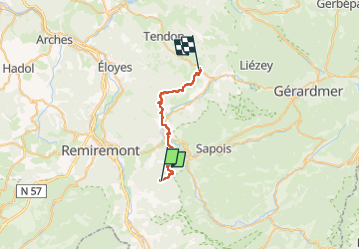
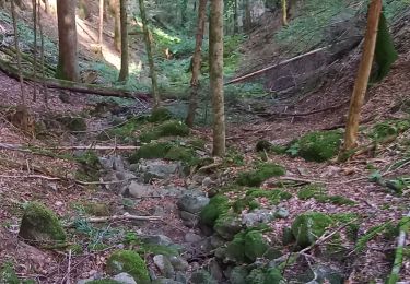
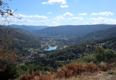
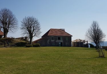
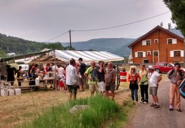
Trail Horseback riding of 22 km to be discovered at Grand Est, Vosges, Dommartin-lès-Remiremont. This trail is proposed by holtzv.
Description
Journée entre les Granges de Franould à Dommartin les Remiremont et Equi'Val au village Le Tholy en passant par la commune du Syndicat
Positioning
Country:
France
Region :
Grand Est
Department/Province :
Vosges
Municipality :
Dommartin-lès-Remiremont
Location:
Unknown
Start:(Dec)
Start:(UTM)
326499 ; 5317614 (32T) N.
Comments
Trails nearby
![Trail Walking Saint-Amé - carrière de Saint Amé - Photo](https://media.geolcdn.com/t/375/260/ext.jpg?maxdim=2&url=https%3A%2F%2Fservices.sitytrail.com%2FGeolivesWS%2FDownloadMedia.ashx%3FTrailID%3D430825%26Media%3D20150607155818.jpg)
![Walking Walking](https://static1.geolcdn.com/sitytour/trail-icons/101.png)
carrière de Saint Amé
Walking
Medium
(1)
Saint-Amé,
Grand Est,
Vosges,
France
![](/images/other/stat-length.png)
8.6 km | 12.6 km-effort
2h 13min
![](https://static1.geolcdn.com/siteimages/upload/files/16400158638029165_repeat_loop_refresh_sync_direction_icon.png)
Yes
![Trail Walking Le Syndicat - Balcon du Solem - Photo](https://media.geolcdn.com/t/375/260/ext.jpg?maxdim=2&url=https%3A%2F%2Fservices.sitytrail.com%2FGeolivesWS%2FDownloadMedia.ashx%3FTrailID%3D109882%26Media%3D4887_1.jpg)
![Walking Walking](https://static1.geolcdn.com/sitytour/trail-icons/101.png)
Balcon du Solem
Walking
Medium
(1)
Le Syndicat,
Grand Est,
Vosges,
France
![](/images/other/stat-length.png)
4.3 km | 7.4 km-effort
2h 0min
![](https://static1.geolcdn.com/siteimages/upload/files/16400158638029165_repeat_loop_refresh_sync_direction_icon.png)
Yes
![Trail Walking Vecoux - Chaudefontaine -grand lac- Chaudefontaine - Photo](https://media.geolcdn.com/t/375/260/ext.jpg?maxdim=2&url=https%3A%2F%2Fmedia.geolcdn.com%2Ff%2Fe2d224f0-cc42-45e2-aa09-2f3731046682.jpg)
![Walking Walking](https://static1.geolcdn.com/sitytour/trail-icons/101.png)
Chaudefontaine -grand lac- Chaudefontaine
Walking
Difficult
Vecoux,
Grand Est,
Vosges,
France
![](/images/other/stat-length.png)
8.6 km | 13.4 km-effort
3h 2min
![](https://static1.geolcdn.com/siteimages/upload/files/16400158638029165_repeat_loop_refresh_sync_direction_icon.png)
Yes
![Trail Walking Saint-Étienne-lès-Remiremont - rando chanoinesses 2024 - Photo](https://media.geolcdn.com/t/375/260/ext.jpg?maxdim=2&url=https%3A%2F%2Fmedia.geolcdn.com%2Ff%2F1f28ad57-0bac-42c5-a239-cee2db707493.jpg)
![Walking Walking](https://static1.geolcdn.com/sitytour/trail-icons/101.png)
rando chanoinesses 2024
Walking
Medium
Saint-Étienne-lès-Remiremont,
Grand Est,
Vosges,
France
![](/images/other/stat-length.png)
12.5 km | 18 km-effort
2h 32min
![](https://static1.geolcdn.com/siteimages/upload/files/16400158638029165_repeat_loop_refresh_sync_direction_icon.png)
No
![Trail Walking Thiéfosse - tiens vagbey gorge de croqery - Photo](https://media.geolcdn.com/t/375/260/ext.jpg?maxdim=2&url=https%3A%2F%2Fmedia.geolcdn.com%2Ff%2Fb2d3ee90-59a2-49f5-a8e0-615370d2ce55.jpg)
![Walking Walking](https://static1.geolcdn.com/sitytour/trail-icons/101.png)
tiens vagbey gorge de croqery
Walking
Medium
Thiéfosse,
Grand Est,
Vosges,
France
![](/images/other/stat-length.png)
8.9 km | 12 km-effort
2h 47min
![](https://static1.geolcdn.com/siteimages/upload/files/16400158638029165_repeat_loop_refresh_sync_direction_icon.png)
Yes
![Trail Walking Vecoux - Chalet avuxon / La Vrille / Col de Xiard variante - Photo](https://media.geolcdn.com/t/375/260/ext.jpg?maxdim=2&url=https%3A%2F%2Fstatic1.geolcdn.com%2Fsiteimages%2Fupload%2Ffiles%2F1553511878bg_sport_marche.png)
![Walking Walking](https://static1.geolcdn.com/sitytour/trail-icons/101.png)
Chalet avuxon / La Vrille / Col de Xiard variante
Walking
Very difficult
(1)
Vecoux,
Grand Est,
Vosges,
France
![](/images/other/stat-length.png)
12.3 km | 19.1 km-effort
4h 20min
![](https://static1.geolcdn.com/siteimages/upload/files/16400158638029165_repeat_loop_refresh_sync_direction_icon.png)
Yes
![Trail Walking Thiéfosse - Randonnée du 23/08/2022 à 17:17 - Photo](https://media.geolcdn.com/t/375/260/ext.jpg?maxdim=2&url=https%3A%2F%2Fmedia.geolcdn.com%2Ff%2Fb0d2cd61-0821-4fc9-9f1c-ed4962685620.jpg)
![Walking Walking](https://static1.geolcdn.com/sitytour/trail-icons/101.png)
Randonnée du 23/08/2022 à 17:17
Walking
Very difficult
Thiéfosse,
Grand Est,
Vosges,
France
![](/images/other/stat-length.png)
18.5 km | 28 km-effort
6h 19min
![](https://static1.geolcdn.com/siteimages/upload/files/16400158638029165_repeat_loop_refresh_sync_direction_icon.png)
Yes
![Trail Walking Saint-Étienne-lès-Remiremont - 20220324_projet_rando_ST-ETIENNE-LES-REMIREMONT_N_Sur_les_pas_de_St_Romary - Photo](https://media.geolcdn.com/t/375/260/ext.jpg?maxdim=2&url=https%3A%2F%2Fmedia.geolcdn.com%2Ff%2F264a1181-fa8b-4d31-b067-498da8b75069.jpg)
![Walking Walking](https://static1.geolcdn.com/sitytour/trail-icons/101.png)
20220324_projet_rando_ST-ETIENNE-LES-REMIREMONT_N_Sur_les_pas_de_St_Romary
Walking
Very difficult
Saint-Étienne-lès-Remiremont,
Grand Est,
Vosges,
France
![](/images/other/stat-length.png)
15.8 km | 25 km-effort
5h 36min
![](https://static1.geolcdn.com/siteimages/upload/files/16400158638029165_repeat_loop_refresh_sync_direction_icon.png)
Yes
![Trail Walking Vecoux - Marche gourmande de Vecoux - Photo](https://media.geolcdn.com/t/375/260/ext.jpg?maxdim=2&url=https%3A%2F%2Fservices.sitytrail.com%2FGeolivesWS%2FDownloadMedia.ashx%3FTrailID%3D431005%26Media%3Dfix__20150607175713.jpg)
![Walking Walking](https://static1.geolcdn.com/sitytour/trail-icons/101.png)
Marche gourmande de Vecoux
Walking
Easy
Vecoux,
Grand Est,
Vosges,
France
![](/images/other/stat-length.png)
10.9 km | 15.3 km-effort
4h 11min
![](https://static1.geolcdn.com/siteimages/upload/files/16400158638029165_repeat_loop_refresh_sync_direction_icon.png)
Yes