


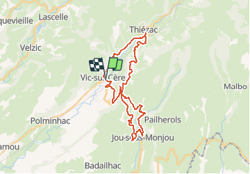
vic sur cere 30KMS

denel
User

Length
31 km

Max alt
1009 m

Uphill gradient
767 m
Km-Effort
42 km

Min alt
662 m

Downhill gradient
768 m
Boucle
Yes
Creation date :
2014-12-10 00:00:00.0
Updated on :
2014-12-10 00:00:00.0
2h21
Difficulty : Medium

FREE GPS app for hiking
 SityTrail
IGN / Geographical institutes
SityTrail Plus
The world is yours!
About
Trail Cycle of 31 km to be discovered at Auvergne-Rhône-Alpes, Cantal, Vic-sur-Cère. This trail is proposed by denel.
Positioning
Country:
France
Region :
Auvergne-Rhône-Alpes
Department/Province :
Cantal
Municipality :
Vic-sur-Cère
Location:
Unknown
Start:(Dec)
Start:(UTM)
470624 ; 4980628 (31T) N.
Comments
Très beau parcours mais avec une grosse erreur qui donne le choix entre un sentier en impasse ou un franchissement quasi impossible de route nationale. C’est dommage et ça nous a fait perdre une demi-heure. La solution est d’aller jusqu’à Thiezac,