


ITI0069

jeanic63
User

Length
10.1 km

Max alt
647 m

Uphill gradient
285 m
Km-Effort
13.9 km

Min alt
447 m

Downhill gradient
285 m
Boucle
Yes
Creation date :
2022-06-07 07:51:54.048
Updated on :
2022-06-07 07:58:39.653
3h08
Difficulty : Easy

FREE GPS app for hiking
 SityTrail
IGN / Geographical institutes
SityTrail Plus
The world is yours!
About
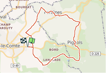
Trail On foot of 10.1 km to be discovered at Auvergne-Rhône-Alpes, Puy-de-Dôme, Vic-le-Comte. This trail is proposed by jeanic63.
Description
départ vers le stade sortie Vic le comte
Positioning
Country:
France
Region :
Auvergne-Rhône-Alpes
Department/Province :
Puy-de-Dôme
Municipality :
Vic-le-Comte
Location:
Unknown
Start:(Dec)
Start:(UTM)
519909 ; 5054396 (31T) N.
Comments