Trail Walking Valdeblore - Le mont Pépoiri - Photo
 franquen
franquen

User

© OpenStreetMap contributors
Length
Length
9.1 km
Max alt
Max alt
2658 m
Uphill gradient
Uphill gradient
639 m
Km-Effort
Km-Effort  
17.6 km
Min alt
Min alt
2031 m
Downhill gradient
Downhill gradient
637 m
Boucle
Boucle
Yes
Creation date :
2014-12-10 00:00:00.0
Updated on :
2014-12-10 00:00:00.0

(0 Reviews)

Walking
Walking
4h03
Difficulty : Medium

Scan this QR Code to open this trail in the SityTrail application

FREE GPS app for hiking

Logo SityTrail SityTrail

IGN / Geographical institutes

Download SityTrail from the App Store Download SityTrail from Google Play

Logo SityTrail SityTrail Plus

The world is yours!

Download SityTrail from the App Store Download SityTrail from Google Play Download SityTrail on Huawei AppGallery

About

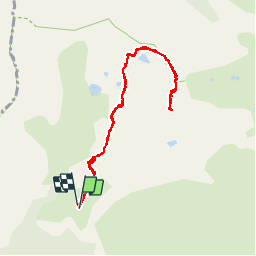
Trail Walking of 9.1 km to be discovered at Provence-Alpes-Côte d'Azur, Maritime Alps, Valdeblore. This trail is proposed by franquen.

Description

randonnée sportive au départ du parking des Millefonts. on longe des petits lacs avant la montée finale à partir du col de Barn. possibilité de faire une boucle par beau temps seulement car sentier peu visible.

Elevation profile

Photos

Positioning

Country:
France
Region :
Provence-Alpes-Côte d'Azur
Department/Province :
Maritime Alps
Municipality :
Valdeblore
Location:
Unknown
Start:(UTM)
354850 ; 4884396 (32T) N.


Close
My subscriptions