


cheminée sambu

brandy
User
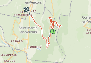

Length
15.8 km

Max alt
1565 m

Uphill gradient
474 m
Km-Effort
24 km

Min alt
829 m

Downhill gradient
963 m
Boucle
No
Creation date :
2022-06-07 09:22:12.354
Updated on :
2022-06-07 15:45:53.336
3h24
Difficulty : Difficult

FREE GPS app for hiking
 SityTrail
IGN / Geographical institutes
SityTrail Plus
The world is yours!
About
Trail Walking of 15.8 km to be discovered at Auvergne-Rhône-Alpes, Drôme, Saint-Martin-en-Vercors. This trail is proposed by brandy.
Positioning
Country:
France
Region :
Auvergne-Rhône-Alpes
Department/Province :
Drôme
Municipality :
Saint-Martin-en-Vercors
Location:
Unknown
Start:(Dec)
Start:(UTM)
694710 ; 4987517 (31T) N.
Comments