


2022-06-08_09h17m35

ludol
User
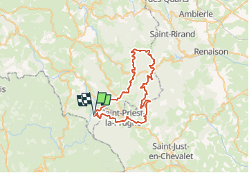

Length
55 km

Max alt
1123 m

Uphill gradient
1684 m
Km-Effort
77 km

Min alt
577 m

Downhill gradient
1659 m
Boucle
Yes
Creation date :
2022-06-08 07:17:35.696
Updated on :
2022-06-08 07:24:04.88
5h20
Difficulty : Very difficult

FREE GPS app for hiking
 SityTrail
IGN / Geographical institutes
SityTrail Plus
The world is yours!
About
Trail Mountain bike of 55 km to be discovered at Auvergne-Rhône-Alpes, Allier, Lavoine. This trail is proposed by ludol.
Positioning
Country:
France
Region :
Auvergne-Rhône-Alpes
Department/Province :
Allier
Municipality :
Lavoine
Location:
Unknown
Start:(Dec)
Start:(UTM)
553816 ; 5090362 (31T) N.
Comments