


Cascade du Pissieu-2022-G2

Valmeinier
User
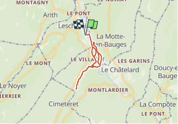

Length
12.3 km

Max alt
686 m

Uphill gradient
203 m
Km-Effort
15 km

Min alt
599 m

Downhill gradient
203 m
Boucle
Yes
Creation date :
2022-06-09 06:08:45.634
Updated on :
2022-06-09 06:08:45.634
3h25
Difficulty : Difficult

FREE GPS app for hiking
 SityTrail
IGN / Geographical institutes
SityTrail Plus
The world is yours!
About
Trail Walking of 12.3 km to be discovered at Auvergne-Rhône-Alpes, Savoy, Lescheraines. This trail is proposed by Valmeinier.
Positioning
Country:
France
Region :
Auvergne-Rhône-Alpes
Department/Province :
Savoy
Municipality :
Lescheraines
Location:
Unknown
Start:(Dec)
Start:(UTM)
275164 ; 5065181 (32T) N.
Comments