


2022-06-10_09h05m45_Landes de Fohet

Gegetop
User
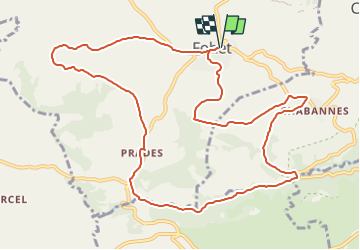

Length
12.5 km

Max alt
962 m

Uphill gradient
250 m
Km-Effort
15.9 km

Min alt
784 m

Downhill gradient
249 m
Boucle
Yes
Creation date :
2022-06-10 07:05:45.96
Updated on :
2022-09-12 15:43:20.039
3h36
Difficulty : Difficult

FREE GPS app for hiking
 SityTrail
IGN / Geographical institutes
SityTrail Plus
The world is yours!
About
Trail Walking of 12.5 km to be discovered at Auvergne-Rhône-Alpes, Puy-de-Dôme, Aydat. This trail is proposed by Gegetop.
Photos

Positioning
Country:
France
Region :
Auvergne-Rhône-Alpes
Department/Province :
Puy-de-Dôme
Municipality :
Aydat
Location:
Unknown
Start:(Dec)
Start:(UTM)
500335 ; 5054305 (31T) N.
Comments