


Moureze 34

raypat
User
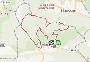

Length
12.4 km

Max alt
522 m

Uphill gradient
517 m
Km-Effort
19.3 km

Min alt
200 m

Downhill gradient
516 m
Boucle
Yes
Creation date :
2022-06-10 08:13:05.253
Updated on :
2022-06-10 15:01:07.291
4h03
Difficulty : Very difficult

FREE GPS app for hiking
 SityTrail
IGN / Geographical institutes
SityTrail Plus
The world is yours!
About
Trail Walking of 12.4 km to be discovered at Occitania, Hérault, Mourèze. This trail is proposed by raypat.
Description
super
Positioning
Country:
France
Region :
Occitania
Department/Province :
Hérault
Municipality :
Mourèze
Location:
Unknown
Start:(Dec)
Start:(UTM)
529090 ; 4829425 (31T) N.
Comments