


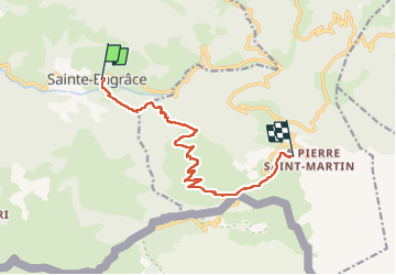
gr10 ste engrâce - la pierre st martin

winkelmuller
User

Length
11.9 km

Max alt
1784 m

Uphill gradient
1211 m
Km-Effort
25 km

Min alt
585 m

Downhill gradient
186 m
Boucle
No
Creation date :
2022-06-09 05:58:54.226
Updated on :
2022-06-10 17:32:39.771
7h32
Difficulty : Difficult

FREE GPS app for hiking
 SityTrail
IGN / Geographical institutes
SityTrail Plus
The world is yours!
About
Trail Walking of 11.9 km to be discovered at New Aquitaine, Pyrénées-Atlantiques, Sainte-Engrâce. This trail is proposed by winkelmuller.
Positioning
Country:
France
Region :
New Aquitaine
Department/Province :
Pyrénées-Atlantiques
Municipality :
Sainte-Engrâce
Location:
Unknown
Start:(Dec)
Start:(UTM)
678572 ; 4762679 (30T) N.
Comments