


Allier jour 2

ludol
User
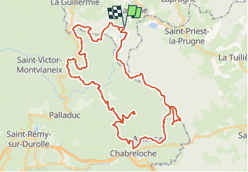

Length
54 km

Max alt
1286 m

Uphill gradient
1657 m
Km-Effort
76 km

Min alt
631 m

Downhill gradient
1654 m
Boucle
Yes
Creation date :
2022-06-11 07:30:24.953
Updated on :
2022-06-11 16:12:40.947
5h41
Difficulty : Difficult

FREE GPS app for hiking
 SityTrail
IGN / Geographical institutes
SityTrail Plus
The world is yours!
About
Trail Mountain bike of 54 km to be discovered at Auvergne-Rhône-Alpes, Allier, Lavoine. This trail is proposed by ludol.
Positioning
Country:
France
Region :
Auvergne-Rhône-Alpes
Department/Province :
Allier
Municipality :
Lavoine
Location:
Unknown
Start:(Dec)
Start:(UTM)
553425 ; 5090550 (31T) N.
Comments