


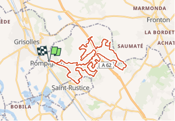
VTT Pompignan 2022

PhilB24
User

Length
24 km

Max alt
218 m

Uphill gradient
288 m
Km-Effort
28 km

Min alt
126 m

Downhill gradient
285 m
Boucle
Yes
Creation date :
2022-06-12 06:49:56.677
Updated on :
2022-07-14 16:17:51.49
1h54
Difficulty : Medium

FREE GPS app for hiking
 SityTrail
IGN / Geographical institutes
SityTrail Plus
The world is yours!
About
Trail Mountain bike of 24 km to be discovered at Occitania, Tarn-et-Garonne, Pompignan. This trail is proposed by PhilB24.
Description
rando VTT 25 km Pompignan juin 2022 par beau temps.
Positioning
Country:
France
Region :
Occitania
Department/Province :
Tarn-et-Garonne
Municipality :
Pompignan
Location:
Unknown
Start:(Dec)
Start:(UTM)
364334 ; 4853093 (31T) N.
Comments