


20220612

fredodlageo
User
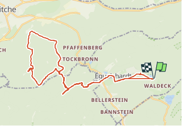

Length
22 km

Max alt
429 m

Uphill gradient
569 m
Km-Effort
30 km

Min alt
243 m

Downhill gradient
573 m
Boucle
Yes
Creation date :
2022-06-12 09:06:45.347
Updated on :
2022-06-12 11:01:31.919
1h54
Difficulty : Medium

FREE GPS app for hiking
 SityTrail
IGN / Geographical institutes
SityTrail Plus
The world is yours!
About
Trail Mountain bike of 22 km to be discovered at Grand Est, Moselle, Éguelshardt. This trail is proposed by fredodlageo.
Description
sortie vtt bitchland
Positioning
Country:
France
Region :
Grand Est
Department/Province :
Moselle
Municipality :
Éguelshardt
Location:
Unknown
Start:(Dec)
Start:(UTM)
392296 ; 5430706 (32U) N.
Comments